Extract : Bates, History of
Adams County, originally published as History of Cumberland and Adams Counties
[Samuel P Bates. History of Adams County,
Pennsylvania. Warner, Beers and Co., 1886 Chicago. 2nd Reprint 1980 by
The Bookmark Knightstown, Indiana. Originally published as History of Cumberland
and Adams Counties-1992 reprint of 1886 edition]
Transcribed by Cynthia Swope for
Within The Vines. All Pages of Within The Vines are
Copyright Protected. See Terms of Use.
|
1] Geography,
History of Cumberland Twp [ pertaining to the Manor of Maske]
3] The
original "Squatters"; their backgrounds, a description of the
group
4] The
original Squatters by name, with some ideas on who they were, and links
to their Within The Vines Identity
IF You have a Forebear Among THE
LIST OF ORIGINAL SQUATTERS, please contact
me
I'd love to link you to the list.
|
ìCumberland Township.
The principal streams of
Cumberland Township are Marsh Creek and Rock Creek. Willoughby
Run, which drains the center of the entire north half, is a tributary of
Marsh Creek, forming a confluence with that stream opposite the Reding
homestead on Toutís farm. A number of running brooks, some with the pretensions
of creeks, flow southeast into Rock Creek, while several rivulets flow
southwest from the center line north and south into Marsh Creek. Rock Creek
bounds the township on the east and marsh Creek on the west, both flowing
south into Maryland within a mile of each other, although they are about
six miles apart in the northern district of the township. Cemetery Ride,
Seminary Ridge, and ROund Top (799 feet above Atlantic Level) are the prominent
eminences.
The geological features are dolerite
on Culpís Hill; trap along Seminary and Cemetery Ridge to Little Round
Top; indurated mud rock, south of Rock Creek bridge; shales and altered
sandstone, indurated mixed rock in rairoad cut west by north of gettysburg;
argillaceous sandstone at brick-yard northeast of Gettysburg; dolerite,
three-quarters of a mile northwest of Gettysburg; and white feldspathic
trap one and one-half miles south of Gettysburg. In 1874 a vein of iron
ore was discovered on Howellís farm, two miles west of Gettysburg. In 1872
iron ore was found on the Peter Gintling farm. Lignite was found opposite
the fair ground at Gettysburg, but the vein was light and quality poor.
Southwest of Round Top is the Indian
field. 56 years ago this was a clearing of six acres in the midst of a
dense forest, with asalt spring at the southern end. Here it is said a
great Indian battle was fought, and this spot was cleared to bury the dead,
although others say it was sacred festival ground. here the Wilsons, McNairs
and Quinns, all of Revolutionary stock, are supposed to have made the first
white settlements in the county.
The population of the township in
1800 was 1, 263, including Gettysburg; in 1810, 863-463 males, 404 females,
2 slaves and 21 free colored. In Gettysburg there were 362 males, 313 females,
7 slaves and 43 free colored, aggregating 725, which with the township
gives a total poulation of 1, 888 sould; in 1820, 1,022, and in Gettysburg,
1,111; in 1830, 1,010, and Gettysburg 1472; in 1840, 1, 218, and Gettysburg,
1.908; in 1850 (excluding Gettysburg), 10455, including 53 foreign and
91 colored citizens. The figures for 1860 and former decennial periods
include the population of part of Highland. In 1880 the population outside
of Gettysburg was 1, 512, and of Gettysburg, 1 2,814.
The number of taxpayers (1886) is
460; value of real estate, $566, 479; number of horses and mules, 464;
cows and neat cattle, 529; value of moneys at interest, $54,905; value
of trades and professions, $11,280; number of carriages, 190;gold watches,
11; silver watches, 1; acres of timber land, 1,956.
In 1809 the stone bridge over Marsh
Creek at Breamís tavern was built by William McClellan, for $2,500.
The length is 115 feet, with five arches. In 1814 the Marsh Creek stone
bridgeo nteh Gettysburg and Emmitsburg road was built by John Murphy. It
is 114 feet long, containsfive arches and cost $3,500. In 1852 it
gave place to the present wooden bridge. In 1846 Joseph Clapsaddle built
the Rock Creek wooden bridge on the Harrisburg road for $850. In 1852 David
S Stoner built a wooden bridge over Marsh Creek on the road from Gettysburg
to Nunnemakerís mill, for 1,544. In 1853 John Finley erected the Rock wooden
bridgeon the Hanover road, near ghGettysburg, for 1, 490. In 1871 the 120
feet span bridge (wooden) at Hornerís mill was rebuilt at a cost of 1,345
by J M Pittenturf. In 1871 Gilbert and Co. erected an iron bridge over
Willoughby Run, on the Gettysburg and Fairfield road, ninety feet long,
for 13.45 per fotot, exclusive of stone work, which was built by Perry
J Tawney. The iron bridge at Hoffmanís, which was being built in the winter
of 1885-6, was swept away and a man named Herring drowned.
The first road repairing work done
in the township after the organization of the county, was in November 1802,
when a small bridge was built over the creek on the Baltimore road near
the millknown as ìMcAllisterís Millî. The first road built after the establishment
of the county was that from IsaacDeardorffís mill to Gettysbur, viewed
in 1800 by Thomas Cochran, Alexander Irvine, Francis Knwouse, Alexandery
Lecky, James Horner and Samuel Smith of Mountpleasant. The Rock Creek road,
otherwise the Baltimore road, an old highway, was repaired fo rthe first
time within the bound of Adams County in June, 1805. During that month
William McPherson and Reynolds Ramsey, the road supervisors of Cumberland
Township, dcalled on the resident for help. This call was responded to
as follows: Rev Alex Doblin (sic, Dobbin), James McClure, Andrew Bushman,
Quintin Armstrong, Robert McCurday (this transcriberís GGGG Grandfather),
David Horner, Henry Black and Conrad Hoke sent each a wagon and team with
one man. Jacob Sharfey , Phoutz J Armstrong, Jacob Bushman, Robert Works,
Hugh Dunwoody, Robert Thompson (possible relationship to this editor as
marrying an aunt Mary McCurdy), Gabriel Wlalker, Robert McCreary, Henry
Black, Michael Miller and Conrad Hoke appeard on the ground themselves,
or sent their men to assist in repairing this road.
The Gettysburg and Blackís Tavern
pike was made in 1812; the Baltimore and Carlisle turnpike in 1815; the
York and Gettysburg and the Chambersburg and Gettysburg pike roads ar enoticed
in the history of other townships.
In 1859 the Gettysburg and Harrisburg
Railroad was opened for traffic. February 26, 1884, the ìJay Cookeî Brought
in the first train over the Gettysburg and Harrisburg Railroad, and two
golden spikes were driven. The road was completeed and opened for regular
traffic April 21, 1884, the first trains north being drawn by the locomotive
ìsouth Mountainî with Samuel Wiser, Engineer; John Sawers, Fireman , anc
Capt Small, conductor. The second train was drawn by engine ìJay Cookeî
with Ephraim McClary, engineer; L Bailey, fireman; Capt C E Givler, conductor.
In 1869 a street railroad was built
from the hanover Railroad depot to the Springs Hotel, right of way being
granted on condition that the company would keep the street in repair.
The conditions were observed for a short time, and in failure the road
was condemned."
Extract
: Bates, History of Adams County, originally published as History
of Cumberland and Adams Counties
|
Footnote
One: Bates entry is confusing. The Conestoga
are generally considered remnant tribes of the once powerful Susquehannock
who , prior to Penn's arrival, had
been decimated by disease and finally, after years of warfare, subjugated
by the Iroquois League. The
period of
the late 17th century to which Bates
is referring is one marked by the dominance of the Iroquois League over
their Algonquian and Iroquoian
neighbors, a process involving almost
3/4s of the 17th century, spanning a huge region of the now United States,
and accelerated and promoted
by the arrival of the contesting
European powers, their guns and desire for trade in furs. In 1696, the
year of Penn's treating with the Conestoga,
the Susquehannocks
had experienced subjugation by the Iroquois for nearly a quarter of a century.
The Conestoga informed
Penn that they were subjugated, and that only the ruling council of
the Iroquois League could determine
the validity of treaty or
land sales involving Conestoga
occupied areas.
See relevant Subject heading and
its many related pages: The
Natives of Southeastern and Southcentral Pennsylvania
The
Manor of Maske, Its Squatters by Definition and by Name:.[Continued
Extract
from Bates History]
|
|
"In 1696 the
five Nations Indians were induced to sell their lands, west of the
Susquehannea, to Thomas Dougan, governor of New York. Immediately after,
Jan 13 1696, the whole tract was deeded to William Penn for 100 pounds
sterling, or about $483. Penn then won from the Susquehannas,
the original owners, their claims, and subsequently satisfied a claim of
the discontented Conestogas, who denied the validity of the Susquehannasí
title see footnote one. In 1736
a deed was given by the five tribes to John Thomas and Richard Penn for
all lands west of the Susquehanna to th 'setting sun'. On this title the
proprietaries claimed the right to own a tract of land as large as Great
Britain, and the claim was held just by the English governors.
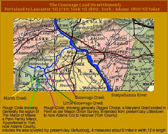
There was also the 'carrol Tract'
and 'Diggesí Choice' located in
Adams County, under titles granted to Carroll and Digges by Lord Baltimore,
but for some years this question of overstepping proprietary rights was
confined to the landlords themselves.
Between 1735-6 and 1741, a number
of Irish peasantry from the hills of Tyrone, Derry, Cavan, and Sligo Counties,
came hither to stay, to erect a free home for themselves at the foot of
the old South Mountains. The Hamiltons, Sweenys, Eddyws, Blacks, McClains,
McCLures, Wilsons, Agnews, Darbey and others were here, near Gettysburg,
in 1841 [sic, 1741]. Then came the landlordsí agent to survey
the ìManor of Maskeî and a second one to drive off the 'Squatters'
or obtain from them pay for the permission to work in the heat of summer
and cold of winter among the rocky hills, who declared 'yt if ye Chain
be spread agaain, he wouíd stop it, and then stop ye Compass from ye Surv
Gen.' The men who resisted the survey of the ' Manor of Maske' were prosecuted,
but the wisdom of the Penns prompted a fair settlement with the squatters,
which resulted in the Irish peasant becoming his own laborer and master,
his own tenant and landlord. This same band of fighters for the right,
organized for defense against the Indians and shared in the honors of saving
the frontier from many an Indian raid. This same band of Peasant first
saw the tyranny of the 'tea tax' and were among the first to hail the Revolution.
They were among the first to recognize the liberty conventions and swear
fealty to the act for such conventions in 1775. They were the men who formed
McPhersonís battalion in 1775, and the Eleventh Pennsylvania Regiment of
the line in 1776.
They spoke bad Irish and as bad English,
but their shout was heard unmistakably wherever the wave of revolution
struck, and when, with their brothers of the thirteen stars, they raised
the flag of the Union, they, at that moment saw the shackles fall from
the husbandman, and industry and liberty march forward over the trails
and military roads cut by the retreating soldiers of Great Britain.
The German Squatters in 'Diggesí
Choice' folllowed up the principle of the squatters in the 'Manor of
Maske' but , making only a formal resistance, were on the point of being
subjected, when Jacob Kitzmiller shot Dudley Digges, a son of the 'landlord'
and routed the sheriff. This act, and the acquittal of the peasant, shed
new light on the land question, and possibly was the second paving stone
in the street which is leading to ownership of land by the cultivator of
the land. Does it not seem strange that here on Marsh Creek, where the
Irish squatter-cultivator first fought for the ownership of his own labor,
the decisive blow was struck at colored slavery 122 years later?"
|
The Squatters
of The Manor of Maske Identified
Readers and Researchers:If
you have a forebear among the THE LIST OF ORIGINAL
SQUATTERS, , I'd love to hear from you and add your link to this list.
Squatters List: [Bates
Transcript Continued- Italicized and/ or indented Editorial Notes are inserted
by this writer and arenot part of the
Original Bates Text ]
|
aaa
"The pioneers of the township [ed note:
Cumberland, Adams County, Penna] came here between 1733 and 1739, from
Ireland. The term 'Scotch-Irish of the border' was a name given to these
settlers by the colonial land grabbers of the Penn coterie (A Boyd
Hamilton, Harrisburg). The tract over which they squatted was wild land
when they came; but a few years later, in 1740, the Penns named it
' The Manor of the Maske.' In 1765 a list of the squatters was made out,
which was recorded April 2, 1792. This list gives the names, and dates
of original improvement of the lands throughout this entire 'manor', and
from it, with the aid of descendants of the old settlers, the following
list of those who resided in this township is taken: "
-
Editorial Notes:
Several
names among those of the original squatters of the Manor of Maske provided
in the Bates History and transcribed below
are relevant to further research for our McCurdy and Allied Lines. They
include
[Thomsons /Thompsons (Andrew
Thompson and
James Thompson,
Paxton (Samuel and son)
and Moore (Joseph and David ] and
I have given thoughts on who they may be within our own family tree involving
the McCurdy and allied families in this portion of those family'shistories.
-
About the Moores in the List:
-
Robert McCurdy's
son James McCurdy married Martha
MOORE, whose ascendancy is not yet known. Included in this roster are
surnames present as collaterols throughout our tree in relation to the
McCurdys and the McCurdy/Moore union. Some of these names, like Robert
McCurdy's children, are present in the transcripts of church
records of Piney Creek Presbyterian near Taneytown, Maryland. Please
note that the Manor of Maske fell very near the region disputed until theMason
Dixon Survey and it is quite possible that those persons relevant but
as yet not identified to us and present in southern Penna thought obtained
their land under Maryland rights, thought themselves present in Md
and vice versa. The Piney Creek Churchin
which many of the following persons are found involved was in fact in northern
Maryland, just south of Cumberland Township, Adams County, Penna and exactly
in the region encompassed by the Survey. Nancy Moor[e] identified
herself as born in Maryland in her census entry of 1850 when she
was residing with her son in law John Adam Swope
and
dtr Nancy Moore McCurdy Swope, his wife. Moore
Entriesin the original Squatter list of the Manor of Maske given below,
when further identified, may yield info on Nancy Moore's ascendancy.
In regards to the Joseph Moor listed in the following list, further research
on this name yields the following. Whether or not they are all referring
to the same Joseph Moor is not known yet to me.
-
"In 1752 the records show there were forty
persons living on tracts sold under Maryland rights, in York County,the
majority of whom were in what is now Adams County, as follows:.....Joseph
Moor" 2
-
There is a Joseph Moor from Md on the Muster
Rolls- Genealogical Records: Maryland Settlers & Soldiers, 1700s-1800s
. Muster Rolls & Other Records of Service, Flying Camp Papers, Page
51 ....Joseph Moor .Enlisted by Ensign Nathan Williams. Passed by Joseph
Smith
|
Again, From Bates"
This list gives the names, & dates of original improvement of the lands
throughout this entire 'manor', and from it, with the aid of descendants
of the old settlers, the following list of those who resided in this township
is taken "
Editorial
Note: Persons of interest to this study are highlighted and expounded upon.
Much of the information is repeated in deference to persons performing
search on ancestors and looking for one person in particular. :
"WIlliam McClellan, May 1740
John Fletcher, June 1739
Robert Fletcher, May 1741
Samuel Gettys (Rock Creek)
1740
Hugh Scott, Sept 1740
Daniel McKeeman Setp 1740
George Kerr, Oct 1740
Samuel McCullough, May 1741
Alex. Stuart April 1741
Robert Smith April 1741
May 1741
[Editorial Note: related
to the Thompsons in Piney Creek Cemetery? Mary
McCurdy, dtr of our Robert McCurdy and Ann Creighton, married Robert
Thompson, and many of her siblings were married by the Rev Davidson and
surrounding the Piney Creek church with which he was associated. There
are family bundles in these smallish congregations, and the McCurdyís seem
to have touched the Clingans, as well as the Thompsons within them. It
would not be suprising for the Paxtons mentioned in Rev Davidsonís records
to be somehow related closely with our McCurdys.There were Paxtons associated
with the Marsh Creek Settlement, but so far any relationship to the McCurdy
line has not yet been established. There is a Robert THOMPSON in the first
tax list of 1799 for the former Manor of Maske in which also appears Robert
McCURDY. Whether or not this James Thompson is an ancestor of that Robert,
or Mary McCurdy's husband Robert, is not yet known}
Joseph Clugston April 1741
John McGaughey April 1741
William McCreary April 1740
, March
1740 [Editorial Note: Does this man yield
possible birth data for Martha Moore married James
McCurdy]
March
1741
[Editorial Note: Does this man yield possible birth data for Martha Moore
married James McCurdy]
Hugh Woods March 1741
Edward Hall March 1741
John Linn 1April 1740
James Walker May 1740
David Dunwoody March 1741
Hugh Dunwoody April 1741
Thomas Douglass May 1740
Alex. Poe April 1739
Hugh Davis April 1739
John Brown May 1741
Samuel Eddy March 1741
John Stuart March 1741
Henry McDonogh April 1739
James McNaught May 1740
Myles Sweeney March 1741
Thomas Boydís heirs, March 1741
, March 1741
Editorial Note: It is
said [see Mellon, Rachel Hughey Larimer's "The Larimers, McAllisters
and Allied Families" published 1903] that
Nancy McCurdy, daughter of our Robert
McCurdy and Ann Creighton ,
married an Unknown Paxton. Many of Nancy's McCurdy siblings were
married by the Rev Davidson and surrounding the Piney
Creek church with which the Reverand was associated. There are
family bundles in these smallish congregations, and the McCurdyís seem
to have touched Piney
Creeks Clingans, as well as
the Thompsons of Piney Creek. It would not be suprising for the Paxtons
mentioned in Rev Davidsonís records to be somehow related closely with
our McCurdys.
Although the exact identification
of Nancy McCurdy's Paxton husband is not yet made, there were Paxtons associated
with the Marsh Creek Settlement [Any relationship to the McCurdy line has
not yet been established]. This samuel Paxton and son, of March 1741, is
probably the Samuel Paxton, born 1760 who, along with three sons,
is known to have been present in the Marsh Creek, now Adams County area.
His father, is reported
ìSamuel Paxton Jr. had been born
in Ireland about 1705 and, when a young man in his twenties, he came to
America with the family. Very little is known of him, except that he was
twice married and was the father of twenty-two children, four of whom died
before their father, which accounts for only eighteen being mentioned in
his will, which was probated, March 8, 1793. However, of the eighteen,
there are only four ? John, Thomas, Jonathan, and Samuel ? on who there
is any data.î from Chapter three of ROCKBRIDGE COUNTY, VIRGINIA Notebook
{Paxton Family Ties}-SEE PINEY CREEK
for expandede info and source references.
Quintin Armstrong, April 1741
John Murphy April 1741
John McNeit, April 1741
John Armstrong April 1740
May
1741
[related to the Thompsons
in Piney
Creek Cemetery? Mary McCurdy,
daughter of our Robert McCurdy and Ann
Creighton, married Robert Thompson, who appears a likely candidate
, along with Mary herself, found within the Thompson graves given in link.
. And many of her siblings were married by the Rev Davidson and surrounding
the Piney Creek church with which he was associated. There are family bundles
in these smallish congregations, and the McCurdyís seem to have touched
the Clingans, as well as the Thompsons within them. It would not be suprising
for the Paxtons mentioned in Rev Davidsonís records to be somehow related
closely with our McCurdys. There are Thompsons also in the congregational
lists for Piney Creek . More discussion on the Thompsons is found on
Piney
Creek page.
John Leard September 1739
Robert Black May 1740
Alex. Walker April 1741
Moses McCarley April 1739
"The Name McPherson does not appear
among the original owners. Robert McPherson was a delgate in the convention
held at Carpenterís Hall, Philadelphia, June 18., 1775, and took the oath
of allegiance to the Union of States; he was also delgate to the great
convention of 1776.
"The act of the Pennsylvania Legislature,
March 12, 1802, dealing with the purchase and improvement of the ìmanor
of the Maskeí prior to 1741, provided that theoriginal settlers, or their
heirs, who were excluded from perfecting titles to their lands, owing to
State and manor boundary difficulties, be now enabled to acquire title
by paying purchase money and interest thereon from 1765 to 1802 to the
receiver-general of the land office. This act applied to the settlers in
Bulter, Menallen, Liberty, Straban, Hamitonban and Freedom, as well as
to the settlers on the east side of Marsh Creek.î2
|
In the Same tome, containing
a list of the original tax payers of the township in 1799 ,
the assessed value of property
are given and Robert McCurdy
is clearly assessed.
|